From the April 2016 Desktop News |A UA professor and graduate student are developing a map of Florida Bay in Everglades National Park in order to help the U.S. National Park Service conserve the fragile environments and animal population within it.
Dr. Michael Steinberg, an associate professor in New College and the Department of Geography, said the map is crucial to slowing the habitat damage caused by boats and other external, man-made forces.
“If you have a lot of boat traffic through the bay, the wakes can destroy nesting sites for birds and sea turtles,” Steinberg explained. “The large population of manatees in the bay are also at risk because of the powerful outboards on these boats.”
The Bonefish and Tarpon Trust commissioned and funded the map to help the National Park Service, which hopes to use the map in order to establish “pole and troll” zones in Florida Bay to minimize boat traffic.
Brad Bates, Steinberg’s graduate assistant and a master’s student studying geography, said that prop scars from boat motors play a part in the destruction of essential turtle grass beds as well. Turtle grass takes seven years to grow back, so when it is destroyed, the sands at the bottom of the bay can become mobile.
“The absence of seagrass causes more wave activity that can destroy habitats,” Steinberg said. “And that’s when you start getting into trouble.”
Steinberg compared it to erosion and desertification on land, with the water currents acting like the wind in deserts.
“Once the current and the tide interact with these barren areas, it’s really hard for seagrass to grow back, and that leads to more destruction and erosion in those areas,” he said.
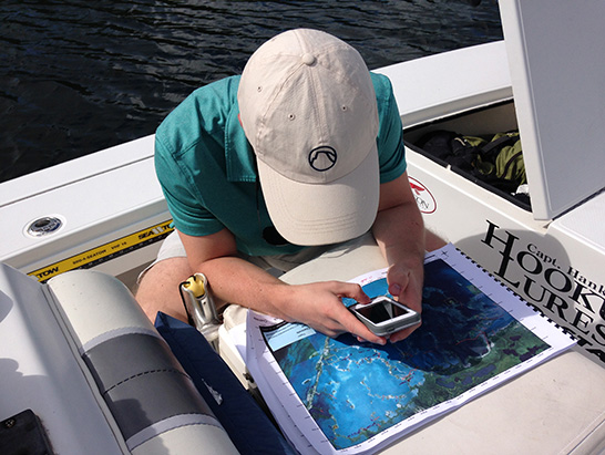
Steinberg and his team don’t just look at satellite images to map the Florida Bay, they actually go to the affected sites themselves to see what is happening. They call the process ground-truthing.
“Satellite images can be very accurate, but even with really good images, you still have to ground-truth certain things,” he said. “But this is a perfect example of spatial technology helping to protect and sustainably manage the environment.”
According to Steinberg and Bates, satellite images can be compromised by things such as cloud cover or a poor picture in one section.
By going to the site and performing the ground-truthing, Steinberg said they learned more about the importance of these areas not only to the animals but also the humans that call Florida Bay home.
“Sport fishing and nature tourism represent millions of dollars to the south Florida economy,” Steinberg said, “so it is critical that we manage the environment sustainably to maintain these benefits and the environment.”